
A sabil (Arabic) was a public drinking fountain or trough that was found at key locations for people to use on their journeys. The word sebil or sabil comes from the Arabic verb root sabala (سبل) meaning “to let fall, drop, to let hang down, to close eyes or to shed tear”. Sabil initially meant “road” or “path” and is used both metaphorically and literally in multiple instances in the Qur’an. Its use as an architectural term for a public water building or fountain likely derives from a more abstract meaning it acquired to refer to general acts or provisions done for the sake of God (such as a charitable act).
This service was free to members of the public, and was paid for by the revenues or funds of a charitable endowment, an Islamic waqf, provided or set up by the patron who commissioned the building. Endowing money for the construction of sabils was considered an act of piety, and the construction of many sebils was considered the hallmark of a beneficent ruler.
A different structure, called a rahat in Hebrew, was also meant for providing water and is mentioned in the Bible:
Genesis 30:38
And he thrust the rods that he had peeled, into the gutters in the watering troughs where the animals would come to drink opposite the [other] animals, and they would come into heat when they came to drink.
וַיַּצֵּ֗ג אֶת־הַמַּקְלוֹת֙ אֲשֶׁ֣ר פִּצֵּ֔ל בָּֽרְהָטִ֖ים בְּשִֽׁקֲת֣וֹת הַמָּ֑יִם אֲשֶׁר֩ תָּבֹ֨אןָ הַצֹּ֤אן לִשְׁתּוֹת֙ לְנֹ֣כַח הַצֹּ֔אן וַיֵּחַ֖מְנָה בְּבֹאָ֥ן לִשְׁתּֽוֹת
Genesis 30:41
And it came to pass, that whenever the animals that were bearing their first would come into heat, Jacob would place the rods in the troughs, before the eyes of the animals, [in order] to bring them into heat by [means of] the rods.
וְהָיָ֗ה בְּכָל־יַחֵם֘ הַצֹּ֣אן הַֽמְקֻשָּׁרוֹת֒ וְשָׂ֨ם יַֽעֲקֹ֧ב אֶת־הַמַּקְל֛וֹת לְעֵינֵ֥י הַצֹּ֖אן בָּֽרְהָטִ֑ים לְיַחֲמֵ֖נָּה בַּמַּקְלֽוֹת
Shemot 2:16
Now the chief of Midian had seven daughters, and they came and drew [water], and they filled the troughs to water their father’s flocks.
וּלְכֹהֵ֥ן מִדְיָ֖ן שֶׁ֣בַע בָּנ֑וֹת וַתָּבֹ֣אנָה וַתִּדְלֶ֗נָה וַתְּמַלֶּ֨אנָה֙ אֶת־הָ֣רְהָטִ֔ים לְהַשְׁק֖וֹת צֹ֥אן אֲבִיהֶֽן
Via Maris
The ancient trade route, dating back to the early Bronze Age, linked Egypt with the northern empires of Syria, Anatolia and Mesopotamia — followed the Mediterranean coast of modern-day Egypt, Israel, Iran, Iraq, Turkey and Syria. The Via Maris is a modern name for this ancient road. In Latin, Via Maris means “way of the sea”, a translation of the Hebrew found in Isaiah 8:23 (9:1 in Christian Bibles).
Isaiah 8:23
For there is no weariness to the one who oppresses her; like the first time, he dealt mildly, [exiling only] the land of Zebulun and the land of Naftali, and the last one he dealt harshly, the way of the sea, and the other side of the Jordan, the attraction of the nations.
כִּ֣י לֹ֣א מוּעָף֘ לַֽאֲשֶׁ֣ר מוּצָ֣ק לָהּ֒ כָּעֵ֣ת הָֽרִאשׁ֗וֹן הֵקַ֞ל אַ֚רְצָה זְבֻלוּן֙ וְאַ֣רְצָה נַפְתָּלִ֔י וְהָאַֽחֲר֖וֹן הִכְבִּ֑יד דֶּ֚רֶךְ הַיָּם֙ עֵ֣בֶר הַיַּרְדֵּ֔ן גְּלִ֖יל הַגּוֹיִֽם
After crossing over from the Sinai, it followed the coast of Canaan through Gaza, Ashkelon, Ashdod and Aphek avoiding the Yarkon River and Dor before turning east again through Megiddo and the Jezreel Valley until it reached Tiberias on the Sea of Galilee. Again turning northward along the lake shore, the Via Maris passed through Migdal, Capernaum and Hazor. From Hazor it crossed the northern River Jordan at what later became known as Jacob’s Ford, then climbed sharply over the Golan Heights and wound its way northeast into Damascus. Here travellers could continue on the King’s Highway as far as the Euphrates River or proceed northward into Anatolia. It was the most important route from Egypt to Syria (the Fertile Crescent).
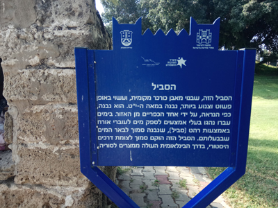
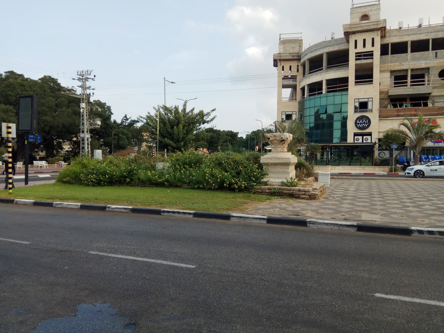
In the nineteenth century, at the entrance to Ashkelon, a sabil was constructed to help people on their journey. This structure still exists today and although it is often overlooked by people turning off the highway to get into the city, it stands among four gas/petrol stations, that might be considered the modern equivalent of the ancient sabil. It is no longer functional although there is a water faucet inside. A blue plaque stands beside it explaining the history. The modern sabils we see today serve a similar purpose as the biblical ones, but were constructed in a different manner.
Avi Sasson, Senior Lecturer in the Department of Land of Israel Studies at Ashkelon Academic College describes the Sabils in his published article Sabils (Drinking Fountains) in the Land of Israel: Geographical-Historical Attributes*:
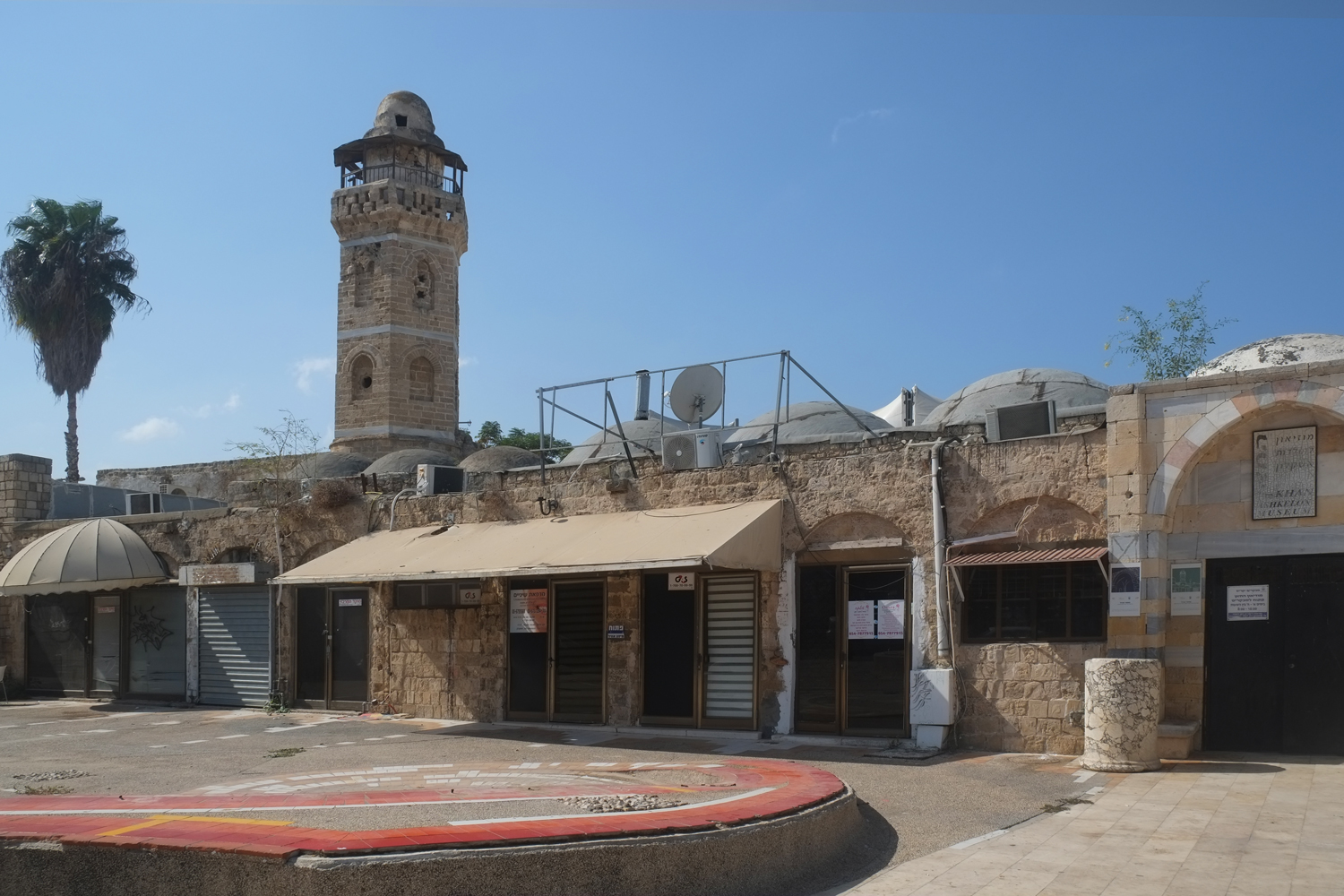
“The practice of providing water for travelers by digging wells, cisterns and reservoirs alongside the roads was already prevalent in ancient times, with traces also found in the Bible and Talmudic literature. The practice continued in the Middle Ages and the Ottoman period. During the medieval period the Muslims expressed these obligations or bylaws in the architectural form of the sabils. The earliest and most impressive sabils in the Land of Israel are those from the Mamluk and early Ottoman periods in Jerusalem, such as the Suleiman sabils, and those in Akko and Jaffa from the late eighteenth and early nineteenth centuries. This article deals with the relics of drinking fountains in Israel which have outlasted the Ottoman period, and so far have not been subject to methodical analysis.”
“The subject of roads in the Land of Israel, both during antiquity and the modern period, has occupied various scholars, mainly in the fields of geographical history and economics. This field of research also covered ancillary services, such as toll collection, roadside accommodations and other facilities. Scant interest has apparently been devoted to services extended to travelers, such as the provision of water (mainly for drinking). Methods for providing potable water, besides the drawing of water by the travelers themselves from roadside cisterns, or the supply of water by local villagers, consisted mainly of public water fountains (rahat in biblical terminology; sabil in Arabic). Many such fountains survived along the Ottoman roads, from which we can learn, not only about the various installations, but also about the complex system of related factors.”
Another, newly restored sabil is found on Eli Cohen Street, just outside of the Ashkelon Academic College.

*ששון, אבי, and Avi Sasson. “Sabils (Drinking Fountains) in the Land of Israel: Geographical-Historical Attributes / סבילים והשקיית עוברי דרכים בארץ ישראל: הממד הגאוגרפי-היסטורי.” Horizons in Geography / אופקים בגאוגרפיה, no. 86 (2014): 65-86. Accessed October 18, 2020. http://www.jstor.org/stable/26597442.


